")
")
 This is a story about a self-planned climb of one of the most beautiful and highest peaks of the Caucasus — Mount Kazbek (5054 m).
For Tanya, this was her first attempt to conquer the summit, for me — the second. My first attempt in September 2011 from the North Ossetia side during the annual Kazbekiada ended in failure: three days of storms at 4200 meters and a descent to the radon springs with a friend who developed pulmonary edema. This time (spoiler alert) everything went successfully, and we want to share our climbing experience, impressions of ascending from the Georgian side, and the joy of reuniting with friends.
This route is more logical and simpler in terms of approaching the assault camp. The technical ascent from the upper plateau (4500 m) to the summit follows a single path, regardless of whether you approach from Russia or Georgia.
So, let’s get started!
Preparation and Journey to Tbilisi
We flew into Tbilisi on June 22 from San Francisco via Istanbul. Climbing Mount Kazbek was only part of our journey. In Georgia’s capital, we reunited with friends after a long separation: Lesha and Leka, Ninochka, Yan, and Marina. Together, we strolled, enjoyed Georgian cuisine and drinks. Details about Tbilisi are in a separate article, but here we’ll focus solely on the climb.
Day One: Tbilisi — Stepantsminda
On the morning of June 25, we set off from Tbilisi to Stepantsminda (formerly Kazbegi), a town at the foot of Kazbek on the Georgian side. Minibuses for 5–7 people depart daily from the Didube metro station, roughly every hour (or as they fill up). The day before, we checked the availability of minibuses. There are two types: those with stops and express buses to Stepantsminda. The express costs 40 lari per person, and the journey takes 3.5–4 hours depending on traffic.
On Wednesday, June 25, we were at the minibus stop by 9 a.m. We got lucky: a driver who lives in Stepantsminda offered to take just the two of us for 100 lari ($35) without waiting for the van to fill up. We agreed, loaded our backpacks, and sped toward the mountains. Along the way, we learned the driver lives in Gergeti, a village above Stepantsminda. For an extra 50 lari, he drove us straight to the Gergeti Trinity Church, where the hiking route begins. We might have slightly overpaid, but the convenience was worth it. The road from Tbilisi follows the Georgian Military Highway, with good asphalt but slow-moving trucks on the Cross Pass, the highest point on the way to Stepantsminda and the Russian border.
After 3.5 hours, we arrived in Stepantsminda. We bought a couple of khachapuri, declined to rent helmets (though we had planned to), and disembarked on a meadow below the Gergeti Trinity Church at 2000 meters. Near the church, there’s a spring with clean water that flows stronger in the afternoon. The driving part of the route was complete.
We spent the rest of the day on passive acclimatization, exploring the area, visiting the church, and reflecting on the route. Kazbek was hidden in clouds that day.
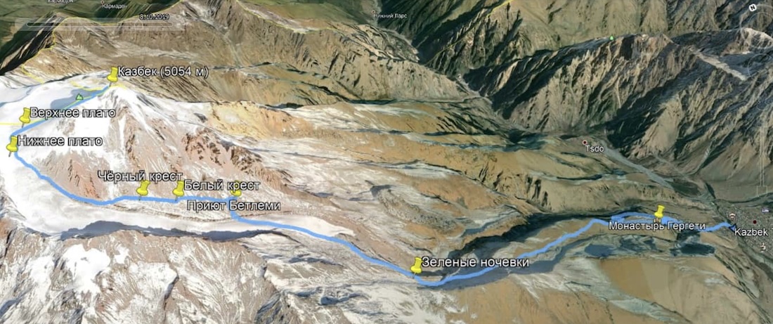
Below is a map of the ascent from the Georgian side, starting from Stepantsminda village, through Gergeti Trinity Church (2000 m), Altihut (Green Camps, 3000 m), Bethlemi Hut (Weather Station, 3650 m), White Cross (3850 m), Lower and Upper Plateau (4500 m), and the summit at 5054 m. The Black Cross and a few tent spots are located below the main trail toward the glacier. We didn’t descend to them.
Day Two: Start of the Hike, Gear Drop at Altihut
For climbing high mountains, there are several acclimatization approaches. One is a rapid ascent, where the body doesn’t have time to react, and you’re already at the summit. But that’s not our method. We chose a slow and gradual altitude gain, which increases the chances of reaching the summit conscious and in good health. The downside is it takes more time and food supplies. We planned for 9 days, including two reserve days.
Another important detail: we arranged to meet friends from Stavropol, a group of hikers, at the assault camp. They were due to arrive in Stepantsminda by July 1. Most of them were already acclimatized, so we wanted to prepare in advance to match their condition and possibly climb together.
After sorting our gear, we realized carrying everything at once would be tough. There were three options:
1. Carry everything at once — heavy, and not everything fit in our backpacks (we carried high-altitude boots separately).
2. Hire horses from Gergeti to Altihut (3000 m) or the glacier’s edge for $150–200 per horse (50 kg of gear). Horses don’t go to the Weather Station.
3. Do gear drops: carry part of the gear up, leave it at a higher point, descend, and then ascend with the rest.
We chose the third option, as we had enough time for acclimatization, and extra hikes didn’t bother us. The plan was:
- Carry half the gear to 3000 m (Altihut), descend to Gergeti, and spend the night.
- Ascend to 3000 m and spend the night.
- Carry half the gear to 3650 m (Weather Station), descend to Altihut, and spend the night.
- Ascend to 3650 m and spend the night.
- Ascend to 3850 m (White Cross, assault camp) and spend the night.
- Proceed based on the weather.
We woke up at 6:30 a.m., had breakfast, packed a gear drop (rope, boots, crampons, harnesses, hardware, some food), and started the trail at 9:30. Kazbek was a stunning sight. The trail from the campsite climbs steeply — the steepest section. After an hour, at 2450 m, we rested at an old meteorological structure. Along the way, we met mostly Russian-speaking hikers. We encountered a group from Kirov — Sergei and his team (hi, Sergei and Lena!). Another hour later, we reached a stone cross and Café 360, a new building with views of Kazbek and the Altihut guesthouse, our goal for the day.
By 12:55, we dropped our backpacks in the Altihut corridor (3000 m). The meadow hosts two guesthouses — Altihut and Deka. Altihut is a renovated building, Deka is new. Both have solar panels, clean rooms, great cafés, and friendly staff. The cost of staying with three meals a day is about $100.
We arranged to leave our gear drop at Altihut for a day (thanks to the staff!). We had tea, a snack, and started descending at 1:50 p.m. By 3:50 p.m., we were back at our tent in Gergeti. The ascent and descent took 6 hours. We had dinner, filled up on water, and went to bed at 8:30 p.m.
Day Three: Altihut
We woke up before 6 a.m., had porridge for breakfast, and started the trail at 7:55 a.m.
Our backpacks were heavier than yesterday, so we moved slower. We reached the meteorological structure in 1.5 hours and took two more breaks. By noon, we arrived at the Deka guesthouse and the tent meadow. We were the first to arrive, with plenty of camping spots. A pipe with clean drinking water flowed nearby, stronger in the afternoon. The Kirov group had gone higher, while we met descending climbers who had reached the summit. Later, a caravan of horses with backpacks and a group of commercial tourists arrived, making it noisy.
This is a busy spot: some ascend, some descend, and many go straight from Stepantsminda to the Weather Station, gaining 1500 m in a day, especially if horses carry their gear. We continued acclimatizing. At night, I had mild altitude sickness with a headache, took ibuprofen, but felt fine overall.
Day Four: Gear Drop at the Weather Station (Bethlemi)
June 28. We woke up at 4:45 a.m. It was cold and clear. Our tent had dew and condensation, though others were dry — a mystery. At 6:50 a.m., we started toward the Weather Station with a gear drop.
By 9:20 a.m., we reached a snowfield on the Kazbek Glacier. The ascent was gentle, and the snow held well. We crossed the closed glacier via the trail and encountered a crevasse with a rushing stream (0.7–1 m wide, 2 m deep). It looked scary, with no one around and fog setting in, but the trail led through it. We didn’t take risks, set up a belay station with an ice axe, crossed with a rope, and threw our backpacks across. It was good practice for setting up stations and belaying.
By 10:50 a.m., we reached the Weather Station (3650 m). The place looked bleak: an old hut, litter, and metal scraps, a stark contrast to Altihut and Deka. Thankfully, clean water flowed from under the glacier. We left our gear drop with the station manager’s permission, took the rope, harnesses, and ice axes, and started descending at 11:20 a.m. We hid the gear in rocks on the glacier to avoid carrying it back. The descent took 1.5 hours, and by 1:00 p.m., we were back at our tent near Deka at 3000 m.
We spent the rest of the day wandering around Altihut. The staff, tired of seeing us, gifted us an almost full gas canister. In the evening, another Kirov group arrived with their instructor, Rodion, from Stavropol. It turned out we went to the same school (No. 15), stood guard at the Eternal Flame memorial in Stavropol, and his mom was our local doctor, whom I even remember! We hadn’t seen each other since school, despite having mutual friends. Hi, Rodion and team!
Day Five: To the Weather Station, Gear Drop at White Cross
June 29. It rained at night. We woke up at 5 a.m., had breakfast, packed the tent, and started toward the Weather Station at 7:00 a.m. By 9:00 a.m., we began the glacier ascent, retrieved our rope and ice axes, crossed the annoying crevasse, and reached the Weather Station by 10:45 a.m. The weather worsened: clouds, rain, snow, and wind. People stayed in their tents. We set up our tent, settled in, and passed the time with conversations, staying upright to avoid headaches.
At 3:25 p.m., we decided to hike to the White Cross (3850 m) to drop gear (ropes, boots, hardware). It took 30 minutes to gain 200 m. The place was much nicer, cleaner, with water and no rain — the clouds stayed below. We left our gear with the Kirov group, chatted, and returned to our tent. We should have moved to the White Cross today instead of stopping at the Weather Station! Live and learn.
The rain resumed, but we were prepared. We had dinner and went to bed early.
Day Six: To the White Cross, Assault Camp
June 30. We woke up at 5:30 a.m. At the Weather Station, it was foggy, windy, with sleet and rain. At 8:40 a.m., we started toward the White Cross. By 9:20 a.m., we were there: sunny, clear, with clouds below. The entire route from Stepantsminda to the White Cross had Georgian LTE signal, allowing us to check the weather (we used mountain-forecast.com) and send messages. The forecast promised a good weather window until noon tomorrow, with winds up to 35 km/h at the summit. After that, the weather would deteriorate for a while. It was a bit risky with such winds, but it was our only option. We decided to go for the summit.
We set up our tent on a ridge with a high stone wall to the north. Above us was a commercial group; below, two Kirov groups. For acclimatization, we hiked to the glacier without high-altitude boots or crampons, traveling light.
After crossing a scree slope, we reached the glacier but turned back upon seeing crevasses. It was unnerving to wander there without a rope. The ascent to the glacier (4100 m) took 1.5 hours, the descent 30 minutes.
By noon, the weather improved as forecasted. We met our neighbors: a commercial Russian group above us had been waiting for a weather window for 4 days. Everyone was preparing for a nighttime start. We went to bed early.
Day Seven: The Ascent
July 1. Altitude sickness hit again at night; I took another ibuprofen. We woke up before midnight: calm, starry skies. At 1:50 a.m., we started on the trail. On the glacier, we switched to high-altitude boots (the soles of mine were detaching, secured by crampons) and roped up. The trail was visible, with groups ahead and behind. We hopped over a few narrow crevasses and reached the upper plateau (4500 m) at sunrise. Two tents stood there; it was very cold and windy. We put on down jackets and super-warm mittens bought for Aconcagua.
From the plateau, the trail zigzags, traversing the slope. The wind covered the trail with snow, but visibility was good. Steep sections were tough, especially with wind in our faces. With the sun warming us and the wind unrelenting, we reached the pass between Kazbek’s peaks. This was a meeting point for determined climbers going up and elated ones coming down. We met a group of three Kirov climbers led by Sergei, descending from the summit after starting at 10 p.m. yesterday. From the pass, a steep, well-trodden trail leads to the summit — the steepest part of the climb, with room to fall. We moved carefully, roped up, at our steady pace.
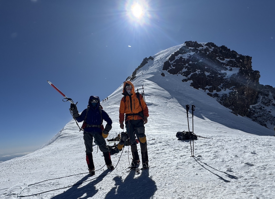
At 7:45 a.m., we stood on the eastern summit of Kazbek!
The summit is a flat mound 10–15 m wide. The mountain was kind to us, though the wind tried to knock everyone off their feet. We took photos, recorded a video, and began the descent. From above, the route looked less daunting, and the wind eased slightly. By 10:30 a.m., we crossed the glacier, and by 12:00 p.m., we were back at our tent. The ascent took 6 hours, the descent 4 hours. The climb to the summit was a success!
In the afternoon, warming up in the sun and sorting our rope, I was suddenly embraced by an unfamiliar, bearded, tanned man. It was Vova Gaivoronsky, the first from our Stavropol friends’ group to arrive, whom we’d been eagerly awaiting! These were our dear friends — Natasha, Andrey, Vova, Pasha, Yasha, Sveta, Slava, and Anton. Hugs, talks, and a feast lasted late into the evening. Our Stavropol friends planned their ascent for the next morning, with the forecast promising a short sunny window with winds up to 50 km/h. After that, the weather looked grim until July 6.
Day Eight: Descent
July 2. In the morning, Kazbek let no one reach the summit. The wind was strong. Groups reached the plateau (4500 m) and turned back. After waiting for our friends, we began the descent at noon.
First to Altihut (3000 m), then to Gergeti (2000 m), and by car to Stepantsminda. The evening in a Stepantsminda restaurant was unforgettable! Walks and conversations on the guesthouse balcony were among the happiest evenings in recent years. Thanks to our friends for the reunion and this adventure!
Following Days
On July 3, we returned to Tbilisi with Pasha, Andrey, and Natasha by car and spent two unforgettable days wandering the city, enjoying Georgian cuisine and wine. Thanks to everyone for this celebration!
Photos from the trip are in one place — photo gallery.
July 12, 2025